Dry Outlook Goes From Bad To Worse
January-April Precipitation Total Is Driest On Record
In a seemingly ever-drier water year like this one, it figures that a bunch of early May rain showers would add up to one of the biggest storms in months. That’s what occurred May 6-8 as a spring storm brought showers of varying, but generally fairly light, intensity to much of California, only a few days after a record was set for the driest-ever San Joaquin Valley January-through-April period.
As has been the case since early winter, what little moisture that the recent clouds managed to produce was a very tiny drop in an extremely large, steadily-emptying bucket.
FOUR CONSECUTIVE DRY MONTHS
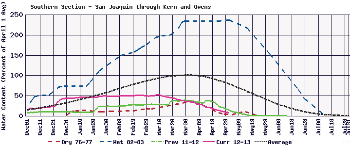
Between the first of 2013 and April 30, an index of five key San Joaquin River watershed weather stations showed only 6.1 inches of precipitation, the lowest ever recorded. As a result, the first four months of 2013 eclipsed the previous record for the same period in the critically dry 1977 water year when 7.1 inches fell.
The dry mid-winter through early-spring conditions are in sharp contrast to wet conditions experienced prior to New Year’s. Fall weather was wet in many parts of the state and carried with it high hopes for a good water year.
Since January 1, California’s precipitation has declined – to practically nothing in many cases. Every monthly measurement in 2013 has recorded a progressively diminishing snowpack and runoff outlook.
All the other statistical signals are just as dry although the California Department of Water Resources has not yet broken out the “drought” label, despite the fact that 2012 was also a much-below-average water year.
The California Cooperative Snow Survey’s May 1 readings showed what little snowpack water content remained was 17% of average for the date. San Joaquin River watershed snow courses were fractionally better, coming in at 24% of the May 1 average. However, little or no snow was present on every course below the 9,000-foot level.
Warm March conditions and hot, dry weather during much of April started the spring snowmelt so early that the calculated natural flow at Friant – the unimpaired San Joaquin River water discharge that would have occurred if there were no dams – peaked April 30. The maximum volume was unimpressive at 5,912 cubic feet per second. That flow figure has since dropped sharply.
RUNOFF FORECAST
Also plunging are runoff forecasts. Based upon the miniscule May 1 snow survey, the California DWR on May 8 predicted – using a “90% exceedance” (extremely dry) scenario – that the San Joaquin River will produce just 340,000 acre-feet of runoff during the crucial April-through-July period of maximum snowmelt, 27.2% of average. Should average precipitation occur through July, DWR indicates the San Joaquin could generate unimpaired flows totaling 490,000 acre-feet, 39% of average.
If it were to become reality, the latest dry-scenario prediction would represent a decrease of 80,000 acre-feet in April-July runoff from the 33% of average, forecast a month earlier.
In their initial prediction made in March, DWR forecasters believed dry conditions would produce April-July runoff of 42% of average with 65% possible if normal precipitation were to occur.
ACTUAL RUNOFF
“Instead, there has been so little storm activity that actual runoff has consistently fallen short of even the 90% exceedance prediction,” said Ronald D. Jacobsma, Friant Water Authority General Manager.
Runoff projections are even lower south of the San Joaquin River watershed. The latest DWR forecast, using the 50% exceedance method (which assumes normal precipitation during the late spring), calls for south valley’s unimpaired runoff from April through July to be:
• Kings River – 35%.
• Kaweah River – 29%.
• Tule River – 13% (lowest of any river among the two dozen Sierra Nevada and Cascades streams upon which DWR issues forecasts).
• Kern River – 18%.
Dry-scenario forecasts indicate the probability of considerably lesser runoff on each river system.
GROUNDWATER RELIANCE
The California Farm Bureau Federation’s Ag Alert quoted Tulare County citrus grower Keith Watkins as saying south valley growers have no choice except to rely on groundwater.
“In a year like this, there are basically very few options,” said Watkins, who is Past President of the Tulare County Farm Bureau and chairs its water committee. “But it’s the future that worries me. We’ll probably squeeze by this year. Another dry year on top of this one, and I don’t know how we’ll make it.”
Watkins farms in 11 different irrigation districts. He said he has installed advanced irrigation systems and relies on both ground moisture sensors and visual inspections to schedule crop irrigation but added he is uncertain how much more he can do. More storage is needed, he said.
WEST SIDE WOES
On the valley’s West Side, where water shortages for years have been created and compounded by fish protection measures under the Endangered Species Act, the situation is back to being grim. Many fields are out of production.
The U.S. Bureau of Reclamation reported its Delta pumps near Tracy have recently been operating at only about 20% of capacity because of dry conditions along with restrictions imposed by other federal agencies to protect fish species such as the tiny Delta smelt. San Luis Reservoir, an important joint storage facility for the State Water Project and the federal Central Valley Project, is about half full.
South-of-Delta farm water allocations for CVP contractors are already down to 20% and there is a fear the declaration could be further reduced further. The State Water Project plans to deliver 35% of contract amounts.
STORM EFFECTS
The recent light rain did knock down irrigation demands for a few days, according to DWR’s Frank Gehrke, while at least briefly slowing down what is left of the Sierra Nevada snowmelt.
Even though valley growers are now struggling with dry conditions, precipitation in the valley at this time of years can cause problems and result in higher production costs due to necessary additional applications of fungicides as well as other rain-related problems.
Valley rainfall ranged from .56 of an inch at the Delano-Earlimart Irrigation District to .60 in Parlier, .42 in Visalia, .38 in Lindcove and Orange Cove, .25 in Visalia, .16 in Arvin, .08 in Fresno, .07 in Madera and .06 at Meadows Field in Bakersfield (although heavier local showers did hit in Bakersfield.
Mountain rainfall also varied but was mostly below .70 of an inch. And snow? There was just enough on the higher ranges to cause the first upturn in weeks on snow sensors.
